
A dangerous stretch of the Mangosuthu Highway near KwaMnyandu Mall, where a two-lane road narrows into a single lane near a busy traffic light intersection, has long posed challenges for motorists and nearby residents. Now attention is also turning to a growing environmental concern just metres away, a landslide threatening part of Umgijimi Primary School.
After some heavy rains a few years ago, a section of the land between the school and the highway was destabilised, triggering a landslide that raised safety concerns for learners, staff, and the surrounding community. The school’s proximity to a road reserve already prone to soil movement has compounded the risk.
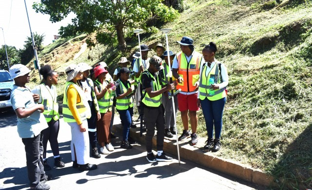
However, relief may be on the horizon. Students and staff from the Civil Engineering and Surveying departments at Mangosuthu University of Technology (MUT) recently conducted a comprehensive survey of the area as part of a hands-on training initiative to address the issue. According to Siyabonga Khanyeza, a Lecturer involved in the project, the initiative was part of a Survey Camp Project designed to benefit students, the affected school, and highway users. “This project was conducted as a service-learning activity and involved about 70 surveying students and six staff members,” Khanyeza explained. “It provided our students with an opportunity to apply theoretical knowledge in a real-world environment, while also assisting the school with critical land and planning challenges.”
Umgijimi Primary School has been grappling with unclear property boundaries, limited topographic data, and ongoing risks associated with its location near an unstable roadside. These factors made it an ideal site for practical training.
During the project, students carried out a full topographical and cadastral survey, using specialised equipment. Cadastral surveys involve mapping and documenting land ownership, boundaries, and property details for legal and planning purposes.
The expected outcomes include accurate site plans, clearly defined boundaries, and detailed spatial data. These will assist the school in future development planning and could inform the construction of a retaining wall to stabilise areas affected by the landslide.
Khanyeza noted that the project is currently in its final stage of registration with the relevant authorities and could serve as a model for similar initiatives in the future. “We see this as a pilot project, with plans to roll it out annually at other sites facing similar challenges,” he said.
The University expressed its gratitude to the South African Geomatics Institute (SAGI) for providing personal protective equipment to students, and to the eThekwini Metro Police for assisting with traffic control along the Griffith Mxenge Highway during the survey work.
As the community awaits the implementation of long-term solutions, the collaboration between the University and Umgijimi Primary School offers a promising step toward improving safety and stability in the area.